Christoph Witzgall, Javier Bernal and Marjorie McClain, ACMD
Douglas R. Shier, Clemson University and ACMD
J. Banchero, Loral Advanced Distributed Simulation (LADS), Bellevue, WA
The ARPA organization is supporting several projects producing advanced distributed simulations of battle fields for training and orientation purposes. NIST has been asked to provide the crucial surface representations covering a 128x172km area of Southern California and, particularly, a 1.5x1.5km maneuver area of the Marine Corps Training Center at Twentynine Palms.
Both projects are continuing, with a first version of the 1.5x1.5km high resolution surface representation already incorporated in a simulation system for dismounted forces operating at Twentynine Palms.
NIST and the Digital Mapping Center at the Computer Science Department of Carnegie Mellon University have independently developed the techniques required for large scale surface representations of this kind. NIST in particular, emphasizes the rendering of surface features such as drain lines, lake shores, roadbeds based on special software written by M.McClain.
The NIST researchers were invited to several workshops concerning these projects. In April, a workshop sponsored by the US Army Topographic Research Center (TEC) at Ft.Belvoir, VA, featured a comparative demonstration of NIST and CMU techniques based on a common test bed. It was repeated at Twentynine Palms in December, where it was combined with a tour of the Marine Corps Training Center terrain.
The capability to perform the necessary surface representations is the result of several years of research in collaboration with TEC. It uses algorithms based on a feature preserving variant of the Delaunay triangulation developed by J.Bernal at NIST coupled with various alternate strategies for selecting ``critical points", that is, vertices for that triangulation. This year, the Delaunay technique was enhanced into ways: (i) a postoptimization step was added to improve accuracy by locally changing the triangulation pattern. (ii) For a fixed triangulation, the elevation at critical points was adjusted iteratively in order to minimize least squares deviations.
Collaboration with the Scientific Visualization group within CAML, in particular, R.R.Lipman proved to be indispensable for evaluating results as well as data. An example visualization is presented in Figure 15 where a simulated terrain is displayed along with a photograph taken in the vicinity.
On the theoretical side, it was observed that planar Delaunay triangulations are characterized by minimizing the sum of the radii of the inscribed circles. A lecture on this topic was presented by C.Witzgall in December at Johns Hopkins University.
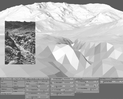
Figure 15: Rendering the ``vadi'' shown in inset as part of
a larger surface representation.